Mementos, Notes, and Fragments
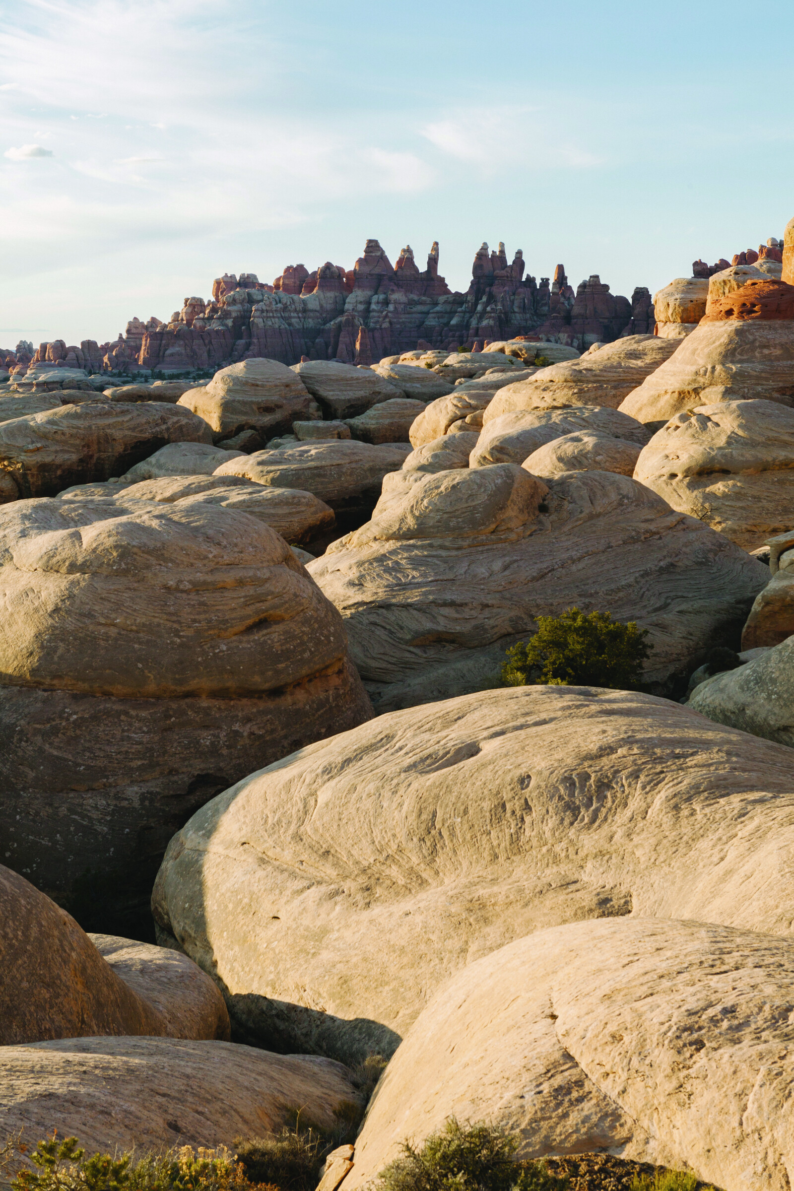
Livestock grazing is a pox on public lands in the American West. Subsidized to the tune of one hundred million dollars a year, cows and sheep roam across two hundred and seventy million acres of federal land, destroying habitat, fouling waterways, endangering native species, and yet statistically adding almost nothing to the nation’s food supply. Anyone who’s ever recreated in the West has witnessed the impact of this scourge.
And yet there’s one place within the purview of Uncle Sam that has never seen hoof nor udder: Tucked into Canyonlands National Park in Utah, blocked by redrock ramparts and accessible only through a narrow, fourth-class scramble, there’s a parcel of two hundred off-limits acres of crimson dirt, centuries-old cryptobiotic soil, and virgin grasslands: an island of lushness in a sea of degradation. Its sixty-two acres of grass are thought to be the largest ungrazed such parcel in the Four Corners area. Which is incredibly sad but makes this spot all the more precious.
Indeed, the area is a gold mine for scientific research, which first began in the 1950s and continues to this day. The public isn’t allowed without a permit or accompaniment of a ranger, and researchers visit just twice a year and stay on restricted paths when they do. “It’s a sense of awe,” said Terry Fisk, chief of Resource Stewardship and Science for the Southeast Utah Group of National Parks. “You get to see the landscape as perhaps it was before Europeans arrived here. And that is vanishingly difficult to do in this day and age.”
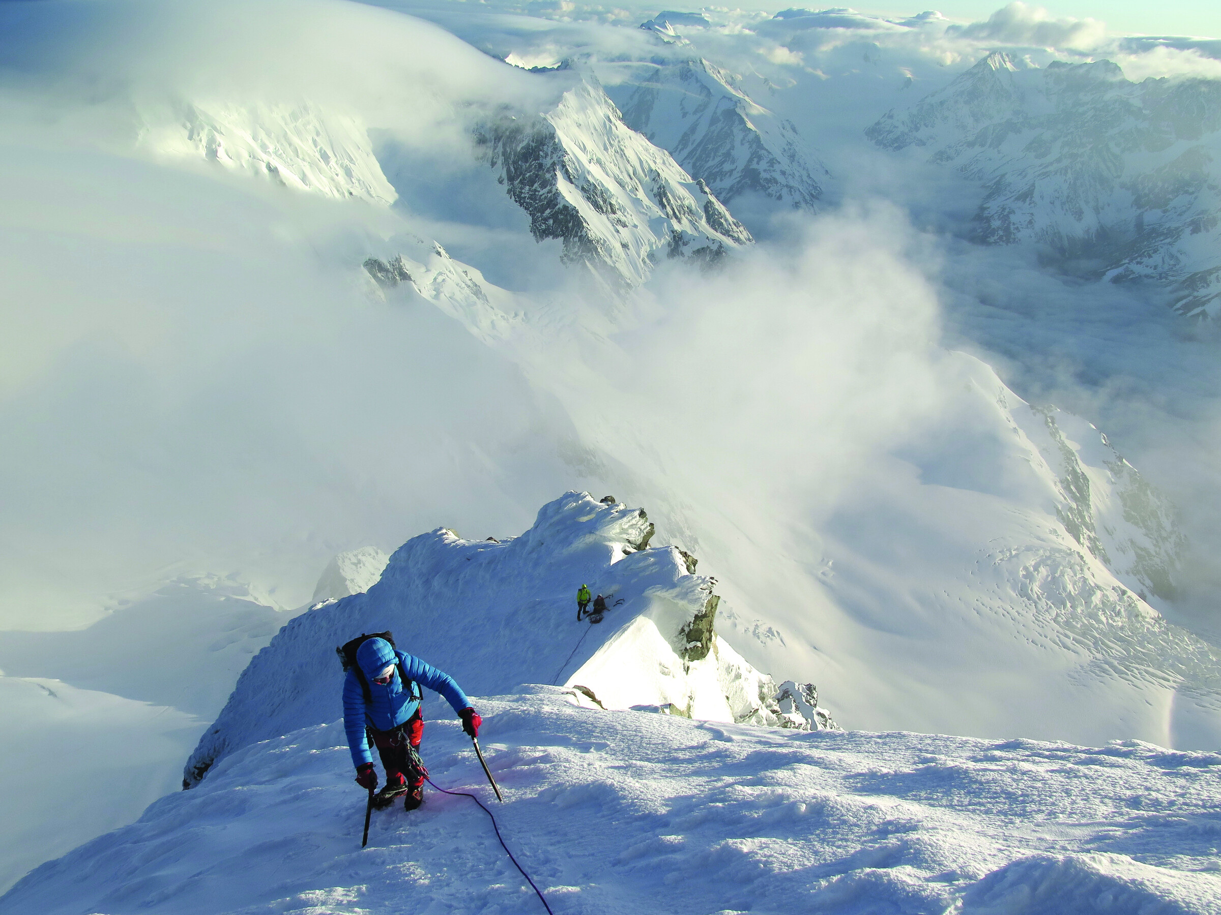
Lots of locations like to lay claim to the world’s worst weather. (Mount Washington, New Hampshire, we’re talking to you.) But few can make a legit argument for full-on conditions like New Zealand’s South Island and, more specifically, the peak that gives Aoraki/Mount Cook National Park its name, which receives the brunt of storms off the Tasman Sea. Consider:
- In the early 1900s, mountain guide Conrad Kain attempted to climb 12,218-foot Aoraki twenty-five times and was turned back by weather on twenty-two of them.
- In 1923, climbers were forced to hunker down in a hut on the Tasman Glacier and wait eighteen days for a series of northwest storms to clear.
- In 1933, a party traversing the Fox Glacier had to take shelter in a crevasse for eight days until they could continue.
- In 1982, Phil Doole and Mark Inglis made it to the summit ridge of Aoraki, where they were trapped for thirteen days by a northwest storm before finally being rescued.
What’s that you say, it’s windy out there? Uh-huh. Doole and Inglis survived by building a snow cave and rationing the few crumbs of food they had. A rescue helicopter carrying seven crashed and flipped (all seven were fine). Each of the two climbers ended up having their legs amputated below the knees due to frostbite. Each also later went back to the mountain and summited, Doole in 2001 and Inglis in 2003. Three years later, Inglis became the first double amputee to summit Everest. How windy was that again?
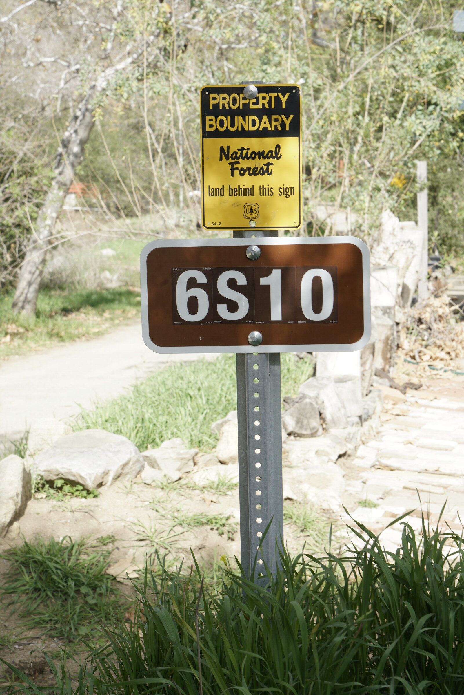
One of the great conundrums to puzzle around the campfire at night is how the U.S. Forest Service numbered the dirt roads that got you to your sweet and isolated campsite. 8N18? 9N29? What the what?
Okay, maybe it’s not a great conundrum, but it’s a common one, because the USFS naming convention baffles most everyone who’s ever tried to navigate forest roads and trails. It turns out, there is logic behind the system, albeit logic only a bureaucrat could love. For the full story we have to go back to 1785, when Rationalism was ascendant. Thomas Jefferson, ever the logician, ordered that the West be surveyed and mapped on a grid rather than relying on natural topography. This led, in the 1870s, to the development of the township and range system for numbering said grid, which led to designations on your topo map like T5N (Township 5 North) or R20W (Range 20 West). Just picture the game Battleship and you’ll get the idea.
The Forest Service glommed onto this system: It names its roads based on the township where the road begins or ends, and those second two numbers indicate the roads from east to west. So, in our sample township above, 5N10 would be the tenth road from the east in Township 5 North. As for trails, the convention is the same, except the service uses ranges and moves from north to south, so 20W01 would be the first trail starting or ending in the north of Range 20 West. Head hurting yet? Here’s an easier rule to remember: When the sign displays its numbers horizontally, the road is recommended for passenger cars; when the numbers are displayed vertically, the road is recommended for high clearance and four wheel drives only.
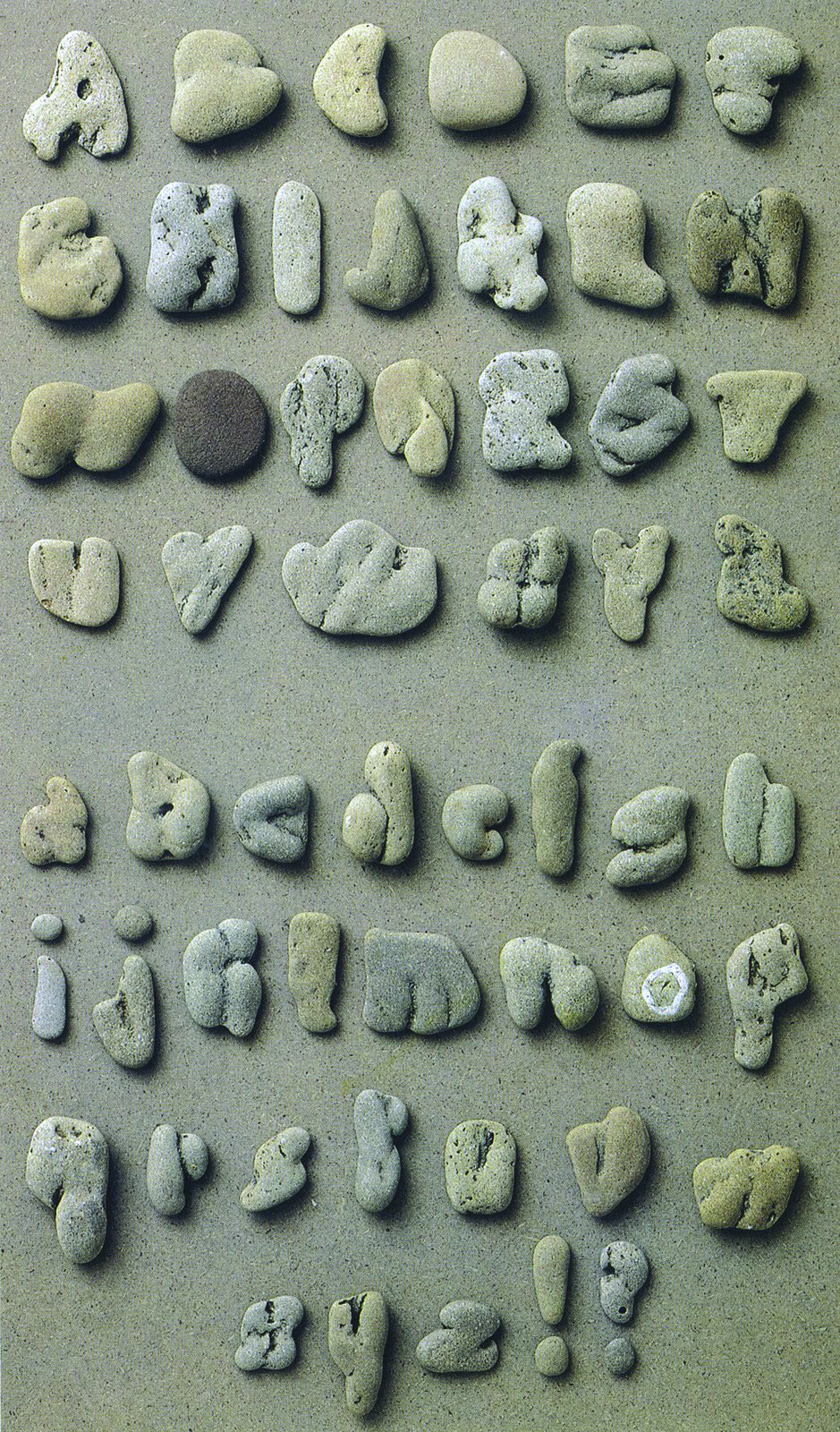
“Pareidolia” sounds like a condition you’d learn about from a pharmaceutical commercial during “Wheel of Fortune,” but in actuality you have it, we have it—everyone has it to some degree. Pareidolia is simply the ability to see shapes, particularly faces, in inanimate objects. Pattern recognition has always been the key to survival, and none other than Carl Sagan said, “Those infants who a million years ago were unable to recognize a face smiled back less, were less likely to win the hearts of their parents, and less likely to prosper.”
Your fate might not depend on finding unicorns in the clouds, but it sure is fun, as is searching for hearts in nature or faces in stone. Clotilde Olyff has taken this to the next level: The Belgian font designer and teacher has made a decades-long hobby of finding letters in rocks, or, if you prefer, rock-like letters. Olyff’s font designs range from geometric to avant-garde, from the sturdy to the whimsical, and it’s not much of a leap to see her attraction to an alphabet that won’t blow away in the breeze.
Olyff has collected letter rocks for decades and around 2000 turned to a writer and designer named Jan Middendorp to create a book of her fonts, including the rocks. “She came to my home office with a few cardboard boxes containing her archive,” wrote Middendorp, “with the simple request to put together (edit, write, design) a booklet about her work. For someone so meticulous about detail, she was surprisingly open to my ideas, and tolerant to my moments of sloppiness. But the color printing (of the pebble pages, and related posters) had to be redone when she (justly) asserted that the colors were off.” Copies of Lettered are nearly impossible to find, but you can always seek out your own alphabet. May the pareidolia be strong in you, Obi-Wan.
42 issues. 11 years. Independently owned. Printed on 70lb uncoated paper with a soft-touch cover, solar-powered, and shipped in a brown paper envelope. Free domestic shipping.