“`
AJ 14 Mementos, Notes, and Fragments
Mementos, Notes, and Fragments

Issue 14
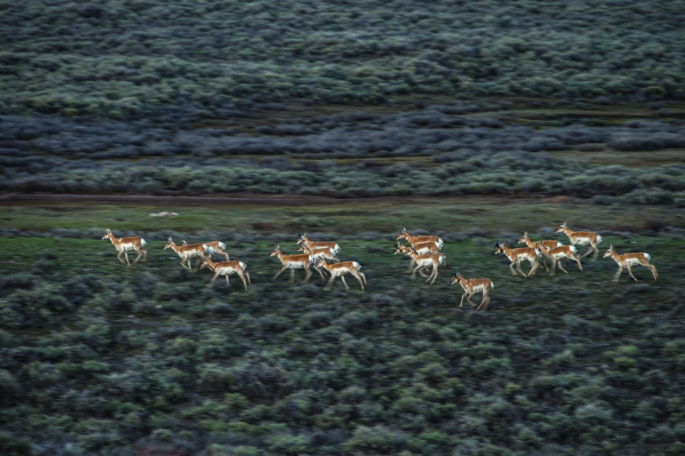
Pronghorn herd
01

On Your Mark, Get Set—Wait, Why Are We Racing When You Know I’ll Win?

Evolution happens for practical reasons. The beaks of Darwin’s finches didn’t get longer because it was trending on social, but because that made it easier to pluck the seeds of cactus fruits. Which makes the speed of North America’s pronghorn, the fastest animal on the continent, a bit of a mystery. Why is this critter so much faster than anything that might chase and eat it? Wolves top out around thirty-seven miles per hour, coyotes around forty-three, and mountain lions around fifty, while the pronghorn can run sixty miles per hour and maintain fifty-seven for nine miles. It could bang out a marathon in just forty minutes, were it so inclined.

Everything about the pronghorn, which isn’t an antelope but is instead related to giraffes and okapis, is designed for velocity and fast escape. Their bones are light. Their lungs are oversized. Their eyes are the largest relative to their body of any American ungulate. Their field of vision is 300 degrees, and they can spot movement four miles away. Their muscles are bigger and leaner and their blood has more hemoglobin to carry oxygen. The pronghorn could thumb its nose at wolves, if it had thumbs. So, what gives?

Biologists think the pronghorn’s speed is a relic trait left over from more than 10,000 years ago, when North America was populated with larger, faster, and more formidable alpha predators like giant short-faced bears, lions, jaguars, and the North American cheetah. Of those, the last gets the most attention, because it could run seventy-five miles per hour, but there was an even scarier creature roaming about: the long-legged hyena. For more than a hundred years scientists speculated that hyenas crossed the Bering land bridge from Siberia but only in summer 2019 was there definitive proof, in the form of two fossilized teeth. “I don’t think there’s a predator alive today,” said Dr. John A. Byers, who wrote a book on pronghorns, “that would’ve been as ferocious as that long-legged hyena would’ve been—its back as high as a person’s waist and running in packs as it probably did.”

To which the pronghorn says: ferocious, yes, but gone…long gone.

Joe Riis
Postal stone inscription from the Dutch ship Middelburg on Nosy Mangabe
02

Letters from the Stone Age

In April 1625, the Dutch ship Middelburg dropped anchor at the tiny island of Nosy Mangabe in the Indian Ocean. After losing its masts and sails in a hurricane, it was desperate for repairs, and for the next six months the crew lived on the 1,300-acre speck, re-outfitting the ship. In October, they sailed for home, but were attacked by Portuguese carracks and all souls were lost.

The Middelburg’s time on Nosy Mangabe would have vanished along with the ship were it not for an inscription left on a boulder and discovered in 2012 by maritime archaeologist Wendy van Duivenvoorde. Called a postal stone, the rock told the tale of the ship’s plight and was part of a messaging network built throughout the seventeenth century by sailors traveling Asian waters. The existence of the stones was common knowledge for centuries, but until van Duivenvoorde began investigating Nosy Mangabe it wasn’t clear just how extensively they were used: Her team found more than forty etchings chronicling the arrival and departure of thirteen ships and it documented stones on Saint Helena and the Cape of Good Hope, too.

The Dutch mariners also placed letters wrapped in waterproof canvas and sealed in tin envelopes beneath the boulders, but these were often stolen by Portuguese sailors, who used their contents to track and outmaneuver the Dutch. Public as a social media post, by the late 1600s postal stones were fading from use—the Dutch turned to simply entrusting locals with letters. Today, Nosy Mangabe is part of Madagascar’s Masoala National Park, and it remains the only place postal stones are found in situ, there to be read by anyone. If you know Dutch, that is.

Mark E. Polzer
Satellite map showing the longest straight-line overland route from Liberia to China
03

The Distance Between These Two Points Isn’t Short

In the winter of 2018–19, an Englishman named Tom Davies attempted to hike across Wales in a straight line. He did it to honor a friend who was murdered while out walking and to raise money for a charity that combats gang violence in the U.K. This got the wheels turning: If one wanted to go overland in a straight line, what’s the farthest you could travel? And where would it be?

Turns out, you would start (or finish) in Africa, on Liberia’s Atlantic coast, and you would end in China at the Pacific Ocean. The distance between those two points is 8,443 miles across eighteen countries and nine time zones. You’d need to add pages to your passport, as you’d travel through Liberia, Côte d’Ivoire, Burkina Faso, Ghana, Burkina Faso (a second time), Niger, Chad, Libya, Egypt, Israel, the West Bank, Jordan, Iraq, Iran, Turkmenistan, Uzbekistan, Tajikistan, Afghanistan, Tajikistan (again), and then China.

Getting visas would be the least of your worries. The route crosses failed states, war zones, and disputed territories. There will be corrupt border guards and possibly roving bands of ISIS fighters. Entering Iran after Israel stamped your passport could be, uh, interesting. Most of Chad is considered a no-go zone, and there aren’t any legal overland border crossings between there and Libya or Niger, the countries on either side of it.

Nutty as that particular route would be, there’s a long tradition of attempting pure point-to-point treks. Italian climbers call the most direct path from the base of a mountain to its summit a direttissima. And none other than Teddy Roosevelt was famous for his ambitious scrambles, where he’d gesture at a distant ridge and then beeline toward it, dragging companions along while proclaiming the motto Over, Under or Through—But Never Around. Teddy, however, it should be noted, didn’t have to contend with ISIS.

NASA
Trucks on Zoji Pass, India Trucks on Zoji Pass, India
04

The Mountain Pass Where Trucks Soar

“Daddy, is that truck supposed to be flying through the air?”

Swiss photographer David Carlier peered out the rain-streaked window of the Tata four-wheel-drive and into the monsoon murk of Zoji Pass, just in time to see one of the multicolored long-haul rigs that carry freight through India’s Jammu and Kashmir state, among the most dangerous and contested conflict zones in the world, disappear over the steep mountainside. Nearly all the trucks that cross Zoji do so on bald tires and with shoddy brakes, and they ferry every kind of product a northern Indian could need, but this one was carrying wheat flour, and as it plummeted under gravity’s pull, a pluming contrail marked its descent to the valley below.

Carlier blanched. Indian truckers often drive with their wives and children, the whole family living in a cab set up as a home space. He turned to look at his wife Laurence in the back seat, along with their four-year-old son Marin, and they looked back out the window.

All they could see was a cloud of white arcing toward the ground.

India’s National Highway 1 runs 262 miles between the old colonial getaway of Srinagar to the Himalayan town of Leh, and the path it follows has never been easy. Up to sixty feet of snow a winter cut Leh and the Ladakh region off from the rest of India for half the year and for the other half Zoji is nothing more than a roughly graded dirt ribbon, its edges friable and crumbling from the weight of overloaded trucks, except when the monsoon hits from July to September and the road turns to greasy, slippery mud a foot deep. Under just about any conditions, this is one of the sketchiest roads in the world, but one that Carlier and his family had to cross to visit the Buddhist Kalachakra Empowerment festival in Leh.

The Carliers witnessed not just one truck fly off the road as they went over the pass, but two, and when they got to the bottom on the other side they found a graveyard of dozens of rusting hulks. But they also got good news. No one was hurt in either incident. The drivers of both vehicles leaped to safety, a Zoji Pass skill even more important than mastering a clutch.

David Carlier
“`
Adventure Journal — Print Quarterly
Stories like this, in your hands four times a year.

41 issues. 10 years. Independently owned. Printed on 70lb uncoated paper with a soft-touch cover, solar-powered, and shipped in a brown paper envelope. Free domestic shipping.

Subscribe — $80/year Or try a single issue for $25

There is nothing else like it. — AJ subscriber